
| Price | Free |
|---|---|
| Category | Tools |
| Version | 1.2 |
| Developer | Oakwood Survey & Mapping, LLC |
| Added | Apr 10th, 2012 |
| App Views | |
| Votes | 0 votes |
| Google Rating | |
| Ratings | 0 |
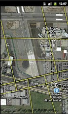
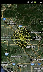
OISView is a GPS and aerial photography based obstruction identification surface viewer. The application plots the user’s GPS position as well as the boundary limits of the desired obstruction identification surface.This demo application is for the Bob Hope Airport (BUR) in Burbank, CA for Runway 15/33. The OIS featured is the FAA AC-150/5300-18B Vertically Guided Approach Slope Surfaces (VGAS), however any airport and set of surfaces can be generated by the developer, including FAR-77 surfaces.For questions or OIS App request, please contact the developer.The surfaces are based on the runway positions published in the FAA FADDS 56-day data set.
App Screenshots
Other Tools Apps