| Price | Free |
|---|---|
| Category | Transportation |
| Version | 1.0.5 |
| Developer | 서울특별시 |
| Added | Apr 14th, 2012 |
| App Views | |
| Votes | 0 votes |
| Google Rating | |
| Ratings | 200 |
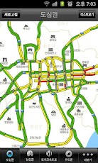
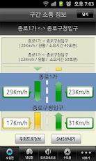
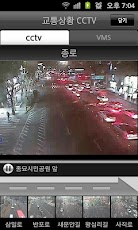
○ “서울 빠른길”은 도심권, 도시고속도로, 남산권, 수도권 교통량의 효율적 분산 및 교통 혼잡을 완화하기 위해 교통상황과 우회정보를 실시간으로 제공하는 교통정보 제공 서비스입니다. http://smartway.seoul.go.kr와 http://topis.seoul.go.kr를 통해서도 서비스가 제공됩니다. 주요기능은1. 서울시 도심권의 주요도로의 소통정보 제공2. 도심권 주요 주요도로의 CCTV 영상 제공3. 주요도로의 돌발정보 제공4. 내부순환도로, 강북북로 등 도시고속도로 소통정보 제공5. 남산 1,2,3호터널 소통정보제공6. 수도권 소통정보제공* 800 x 480 해상도에 최적화 되어 있으며 해상도가 다를 경우 화면이 깨질 수 있음 (갤럭시 S, 갤럭시 S2, 넥서스 S 등에 최적화 되어 있음)○ "Seoul quick way" the urban areas, urban highways, Nanshan Issues, capital efficient distribution of traffic and to alleviate the traffic congestion, traffic and detour traffic to provide real-time information is the information service. http://smartway.seoul.go.kr and http://topis.seoul.go.kr through the service. The main feature1. Urban area of Seoul, the main road traffic informationTwo. CCTV footage of the main road provides the main urban areasThree. Break out of the main road informationFour. Inside the Beltway, North Road, Jiangbei highway and urban traffic informationFive. 1,2,3 Namsan Tunnel traffic informationSix. Metropolitan communicate information* 800 x 480 resolution and is optimized for screen resolutions are different can be broken (Galaxy S, Galaxy S2, Nexus S optimized for speed)
App Screenshots
Other Transportation Apps