
| Price | $9.99 |
|---|---|
| Category | Transportation |
| Version | Varies with device |
| Developer | Olivier Donati |
| Added | Apr 6th, 2012 |
| App Views | |
| Votes | 0 votes |
| Google Rating | |
| Ratings | 48 |
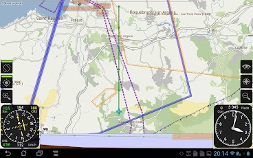
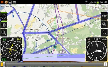
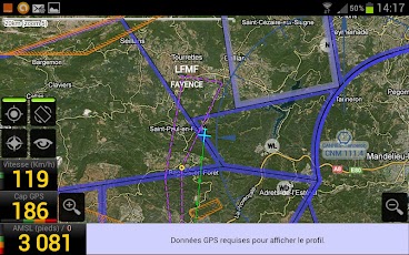
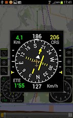
Application d’aide à la navigation aérienne à vue en France pour les téléphones et tablettes sous Android 2.1 et +.Elle est particulièrement adaptée à la navigation en ULM, planeur ou avion léger.ATTENTION : Les données aériennes disponibles dans VFR ne couvrent que la France métropolitaine et la Corse. La vente de VFR n’est ouverte à l’étranger que pour satisfaire la demande des pilotes francophones qui souhaitent utiliser VFR à l’intérieur du territoire Français.Fonctionnalités :* Affichage de la position GPS sur un fond de carte – Google Maps (en vue "carte routière" ou en vue "photo satellite" pour les appareils compatibles et à condition d’être connecté à internet via un abonnement 3G). – Embarqué basé sur des données OpenStreetMap à télécharger (en vue orientée nord ou orientée cap).* Enregistrement de la trace GPS et export au format KML.* Affichage de la vitesse (en km/h ou en noeuds), du cap et de l’altitude en pieds par rapport au niveau moyen de la mer (AMSL) ou par rapport au niveau estimé du sol (AGL).* Possibilité de choisir les instruments affichés ainsi que leur disposition à l’écran par fichier de configuration.* Possibilité de saisir une correction de l’altitude lue par le GPS pour tenir compte du GUND (non sphéricité de la Terre).* Affichage, en surimpression de la carte, du contour des zones aériennes de France avec un code couleur en fonction de leur classe.* Affichage des aérodromes, des bases ULM, alti-surfaces, vaches planeur identifiés par leur nom et un code couleur.* Affichage des points de report des aérodromes.* Affichage des pistes des aérodromes en surimpression de la carte avec indication de la position de leur seuil et de leur dénomination.* Affichage des VOR, TACAN et NDB définis dans les AIP ENR 4.1 du SIA.* Affichage en "tapant" sur la carte, des informations sur ce point : coordonnées, élévation, zones, infos AD et carte VAC ou fiche BASULM si disponible pour un AD.* Téléchargement et mise à jour des cartes VAC et fiches BASULM directement depuis l’application.* Affichage d’une vue de profil en avant de la trajectoire de l’avion avec le relief du sol et les zones aériennes.* Visualisation de la projection de la trajectoire actuelle à 5 minutes avec un repère toutes les minutes sur la carte et sur la vue de profil.* Possibilité de créer et enregistrer des routes constituées d’une succession de points avec consigne de vitesse et d’altitude.* Possibilité d’importer une route au format GPX ou créée à partir du logiciel Navigation de François Fouchet (Foufou) qui accepte maintenant également l’import des traces de VFR.* Possibilité de lister les aérodromes à proximité et d’afficher la route directe pour s’y rendre ou pour se rendre à un de ses points de report.* Affichage de l’écart de navigation par rapport à la route active (en vitesse, cap et altitude) via des indicateurs de couleur ou un HSI.* Affichage du temps estimé pour le prochain point, pour la fin de la route et du cap à suivre pour le prochain point.* Passage automatique au point suivant de la route en arrivant à proximité du point actif ou sélection manuelle du point actif.* Possibilité de "rejouer" une trace GPS enregistrée pour simuler un fonctionnement réel en navigation et "prendre en main" l’application, avec un mode pause et un curseur permettant l’avance rapide et le retour arrière.* Prise en charge des orientations "portrait" et "paysage" de l’appareil.Helper application to visual air navigation in France for phones and tablets running Android 2.1 and up.It is particularly suited for navigation in a microlight, glider or light aircraft.CAUTION: The air data available in VFR only cover mainland France and Corsica. Selling VFR is open to foreign as to meet the demand of French pilots who wish to use VFR inside French territory.Features:* Display GPS location on a map background – Google Maps (for "road map" or to "satellite view" for compatible devices and you must be connected to the Internet via a 3G subscription). – Embedded based on OpenStreetMap data to download (in north facing oriented course or view).* Registration of GPS track and export to KML.* Display speed (km / h or knots), heading and altitude in feet above mean sea level (AMSL) or relative to estimated ground level (AGL) level.* Ability to choose instruments and displayed them on the screen configuration file.* Ability to enter a correction of the altitude read from the GPS to reflect GUND (non-sphericity of the Earth).* Display, superimposed on the map, contour aerial parts of France with a color-coded according to their class.* Display airfields, bases ULM, alti-surfaces, cows glider identified by name and a color code.* Display checkpoints airfields.* Display runway pattern superimposed on the map showing the position of their threshold and their designations.* Display VOR, NDB and TACAN defined in AIP ENR 4.1 SIA.* Display "tapping" on the map, information on this point coordinates, elevation, area, map and info AD VAC or plug BASULM if available for AD.* Download and update maps and VAC BASULM sheets directly from the application.* Display a profile view of the front of the path of the aircraft with the relief of the ground and air zones.* Visualization of the projection of the current trajectory to 5 minutes with a mark every minute on the map and the profile view.* Ability to create and save routes consist of a sequence of points with set speed and altitude.* Ability to import a route in GPX format or created from software navigation François Fouchet (Fufu) now also accepts import traces of VFR.* Ability to list the airports nearby and display the direct route to get there or to go to one of its checkpoints.* Display the gap navigation compared to the active route (speed, heading and altitude) via color indicators or HSI.* Display of the estimated for the next point, the end of the road and the course to follow for the next time point.* Automatically switches to the next point on the route arriving near the active point or manual selection of the active point.* Ability to "replay" a GPS track log to simulate a real operation and navigation "take over" the application, with a pause and a slider to fast forward and rewind.* Support Guidelines "portrait" and "landscape" of the device.
App Screenshots
Other Transportation Apps